
Littlejohn Island Preserve
Description
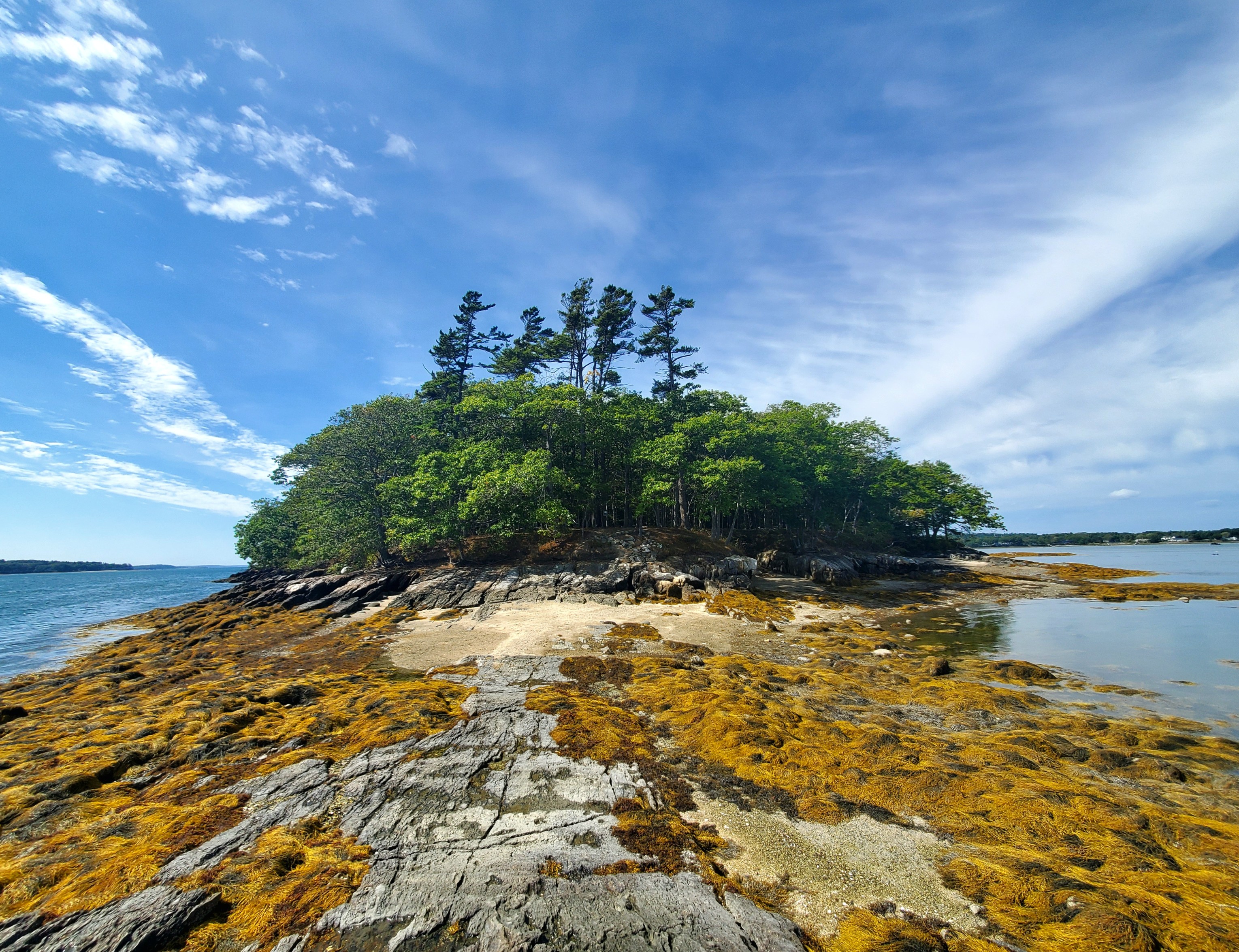
Nestled on the shores of Casco Bay in Yarmouth, the quiet 23-acre Littlejohn Island Preserve is one of RRCT's most beloved preserves. Littlejohn Island Preserve is home to stately red oaks that offer perches to bald eagles and great horned owls, secluded rocky beaches, and breathtaking ocean-front views. Along the preserve’s 1-mile loop trail, visitors will find scenic viewpoints, tide pools, ledges, picnic tables, and benches.
RRCT's Pemasong Lane 4-car parking lot is at capacity most days and most times of day due to strong demand. Access by bicycle or water, are ideal alternatives to limited vehicular parking.
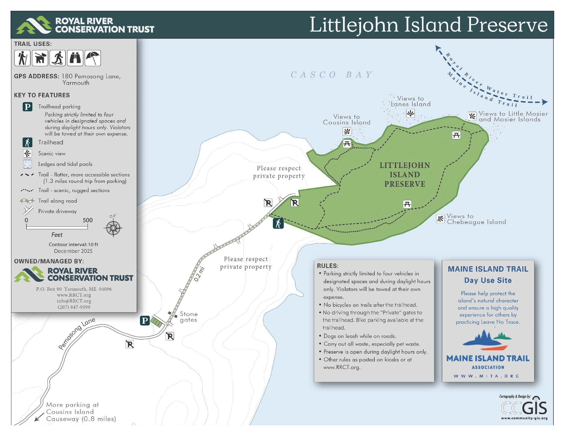
4-car Parking Lot: 180 Pemasong Lane, Yarmouth
1.3 mile trail network


More information
This preserve is a day-use, water-access, picnic spot listed as part of the Maine Island Trail and the Royal River Water Trail.
The 1.3-mile loop trail is largely flat, wide, dry and well-maintained. The first part of the trail follows a plowed private gravel road. This is an easy, family and dog-friendly walk ideal for birdwatching, wildlife viewing, and quiet picnics. Dogs must be leashed on the road to the preserve and under strict voice control in the preserve. There are no restrooms, and bikes aren’t allowed on the trails.
The terrain is mostly flat with boardwalks, bog bridging, benches, and picnic spots along the way. Short spur trails to the shore are rockier and may be slippery. The inside loop of the trail is relatively accessible for rugged baby carriages, walkers, and the most rugged wheelchairs although roots and rocks can create trip hazards. Along the trail are three picnic tables (including one constructed for wheelchair compatibility) and five benches. There are also two boardwalks, two small bridges, and many bog bridges. The preserve has no bathroom facilities.
View this trail on:
Parking: There is a 4-space parking lot and kiosk at 180 Pemasong Lane, Yarmouth ME. The parking lot is open only from dawn to dusk. Parking is typically at capacity at all times; please visit our other preserves, or plan to walk or bicycle. When the parking lot is full, visitors arriving by car must turn around and go elsewhere or find parking off-island. Do not park along the shoulders of Pemasong Lane or at the end of the road. Please be aware that neighbors have the authority to tow parking violators, consistent with their posted signs.
Directions from RRCT Parking Area: The trail from the parking lot begins by walking along Pemasong Lane through the stone gates marked “Private.” After 2/10 miles walking on Pemasong Lane, you'll see a blue sign and trailhead on the right, just before the end of the lane. Bike racks are available at the trailhead. All driveways off Pemasong Lane are private. Please do not walk or drive down any private driveways.
Alternative Parking Locations, Non-Vehicular Access: RRCT owns only one small parking lot, described above. There is almost no other legal parking for preserve users anywhere on Littlejohn Island. If the RRCT parking lot is full, as it often is, or for a better longer trip, please return to either Cousins Street, Cousins bridge, or the Cousins Island side of the Littlejohn causeway (Talbot Road) for parking, or explore other beaches and preserves.
- Parking at the Littlejohn Causeway (Talbot Road on Cousins Island): Roughly four parking spaces exist on Talbot Road (Cousins Island) on one side of the Littlejohn Causeway. Parking at this location extends your Preserve visit to a longer round trip hike (3.0 miles) and allows a walk along the tidal mudflats.
- Parking on Cousins Street (Cousins Island). On-shoulder parking is legal on portions of Cousins Street, the main street on Cousins Island. Parking at this location extends your hiking trip to roughly 3.5 miles round trip.
- Parking at the Cousins Causeway/Bridge (Sandy Point Beach): Ample free parking exists at Sandy Point Beach on Cousins Road (Cousins Island) roughly two miles from the Preserve. Sandy Point Beach and the preserve are connected by the West Side Trail (off-road, some shoreline) for biking, hiking, and running. Bring your bike or hiking/running shoes and enjoy a six-mile round trip.
- Access by water: Kayak access is a great way to explore the preserve. Access by motorized boats is risky due to tides and depths. Free kayak put-in is available at Sandy Point Beach and elsewhere.

Seventeen acres of the 23-acre preserve were protected in 1990 by a conservation easement with no guaranteed public access. In November of 2006, the entire 23 acres was acquired by the Royal River Conservation Trust to secure public access and open space. Stone stairs to the ocean were installed in 2012 and 2017, each time with the assistance of the Maine Conservation Corps. A new expanded parking lot was built in 2015 by neighbors and deeded to RRCT. A bronze interpretive panel identifying islands in the view from the point was installed in 2018.

- The preserve is open during daylight hours for hiking, snowshoeing, and backcountry skiing. Dogs are welcome on leash on Pemasong Lane and under voice control in the preserve, leaving no evidence of their visit.
- Parking is strictly limited to four vehicles in the designated spaces in this lot. No parking, idling, or waiting on road shoulders. Please do not drive through the “Private Way” gates to the trailhead. Veichles parked on private land or road shoulders will be towed at the owners’ own expense by private landowners.
- Dogs must be on leash on Pemasong Lane and under strict voice control in the preserve. Please do not let dogs chase wildlife or wildfowl.
- No bicycles on trails after trailhead way station, where bike racks are available.
- Boat launching from the preserve is not allowed. Paddlers may launch elsewhere and paddle to the property for daytime picnics. All docks are private; the preserve has natural landing stops only
- Use only established paths to help prevent erosion. Hunting is not permitted, except for RRCT-selected bow hunters participating in deer-management efforts. Temporary preserve closures for bow hunts will be posted here. All hikers should wear blaze orange during hunting season.
- No camping, overnight parking, fires, or smoking.
Spring mud season postings: During mud season (typically March–April), Pemasong Lane and this parking lot may be closed to vehicle traffic (except for Pemasong Lane residents) to protect the road surface.
The land that is now the Littlejohn Island Preserve is part of the ancestral land of the Abenaki. For thousands of years, the Abenaki and other shifting tribes and cultures used Littlejohn and the islands of Casco Bay as a late winter and spring source of food, spending seasons year-after-year on the islands harvesting oyster, seals, and more. This history is recorded in shell middens and archaeology, oral history, and other sources.
In early 2022, RRCT identified a shell midden within the preserve, near the point. Following consultation with Abenaki voices and several Wabanaki residents now living in Yarmouth, RRCT authorized archeologists along with volunteers from YCARE (Yarmouth Racial Equity) to excavate test pits to learn more. Along with expected shells, we found human-made shards of Kineo rhyolite, chertz, and quartz (for example from production of tools or arrowheads), charcoal likely from cooking fires, and more. We also found ceramic fragments from the ceramic era (post-Archaic), and a significant quantity of bone (not human), not-yet analyzed, especially on the southern edge of the site.
“Little John” refers to John Cousins, also the namesake of Cousins Island and the Cousins River. Among the earliest European colonizers in Yarmouth, Cousins soon left Maine wrapped in narratives of incidents of violence.
Habitat
Littlejohn Island Preserve is dominated by an oak – pine forest in most areas up to the coastal beach natural communities. Tidal mudflats are present on the northwestern shores of the preserve while steeper, rocky coastlines wrap around the point and along the southeastern portion of the preserve. Secluded rocky beaches are dispersed along the coastline, perfect for ocean dips.
The preserve also hosts a concentration of migrant birds and is a site for the Morning Flight Phenomenon. Common eiders, black guillemots, ospreys and bald eagles are regularly present in and around the preserve.
Management Plan
Learn more

Littlejohn Island Preserve
Nestled on the shores of Casco Bay in Yarmouth, the quiet 23-acre Littlejohn Island Preserve is one of RRCT's most beloved preserves. Littlejohn Island Preserve is home to stately red oaks that offer perches to bald eagles and great horned owls, secluded rocky beaches, and breathtaking ocean-front views. Along the preserve’s 1-mile loop trail, visitors will find scenic viewpoints, tide pools, ledges, picnic tables, and benches.
RRCT's Pemasong Lane 4-car parking lot is at capacity most days and most times of day due to strong demand. Access by bicycle or water, are ideal alternatives to limited vehicular parking.