
Old Harris Road Preserve

Description
The 14-acre Old Harris Road Preserve is managed primarily for habitat and ecology. It contains a key area snowmobile trail connection as well as an outdoor classroom and highly interpretive trail built for the students and faculty of Pownal Elementary School.
604 Elmwood Road, Pownal (across from Pownal Elementary School and adjacent to Elmwood Cemetery)
0.6-mile trail (1.2 miles round trip)


More information
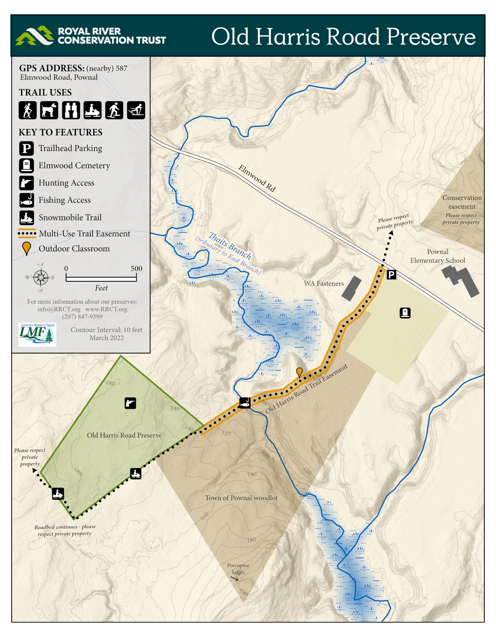
The preserve is located across the road from the Pownal Elementary School and adjacent to the Elmwood Cemetery.
The 0.6 mile out-and-back trail departs from 604 Elmwood Road in Pownal just west of the Elmwood Cemetery. The trail runs along a peaceful woods road, providing hiking and snowmobile access to the preserve and its outdoor classroom as well as to Thoits Branch. Parking is available on the shoulder of Elmwood Road.
The trail segment from the road to the outdoor classroom is maintained for casual walking but is not maintained for wheelchairs or other devices. The trail segment after the classroom is steeply sloped as it approaches Thoits Branch. Crossing the snowmobile bridge requires careful footwork. ATV use is prohibited due to steep slopes prone to erosion. The snowmobile trail continues onto private land after leaving the preserve; many landowners permit snowmobile use only.
Old Harris Road Preserve was established in 2007 with the goals of preserving habitat and providing recreational access, including the perpetuation of a snowmobile trail.
In the 1940s, Pownal rejected proposals to dam Thoits Branch in order to create Lake Pownal to enhance the new Bradbury Mountain State Park. Old Harris Road shows on maps as recently as the 1940s but disappears from maps by the 1960s. Stone walls line parts of Old Harris Road on the preserve.
Permitted: Fishing, hiking, hunting, outdoor classroom activities, skiing, snowmobiling, snowshoeing, and trapping (with advance notice). Dogs (on leash or under voice control – leash only near the road and during periods of deep snow), leaving no evidence of their visit.
Hunting: Safe and responsible hunting is permitted with notice. Please review RRCT's Hunting & Trapping Rules and annually register to hunt on RRCT property the online registration form linked here. All trail users should wear blaze orange during hunting seasons.
Not permitted: ATV use, biking, equestrian activities, and smoking.
Required: Wear blaze orange during all hunting seasons. Adherence to postings on private abutting land; many of these postings seek to protect nearby farm animals from dogs and hunters.
Royal River Conservation Trust protects and stewards properties, including Old Harris Road Preserve, located within the traditional homelands of the Wabanaki. We strive to ensure that our properties are inclusive and accessible and provide opportunities for healing, education, and respite.
RRCT and Pownal Elementary School have partnered to draft the Interpretive Nature Trail Guide for Old Harris Road Preserve. The guide, written for elementary students, contains useful information about the preserve and is updated by students and teachers periodically.
Habitat
Red oak, hemlock, and white pine are the most common tree species on the preserve. Several other tree species, including bigtooth aspen, American beech, red maple, sugar maple, white ash, paper birch, red spruce, and balsam fir, are also present. The forest floor is healthy with downed trees and nurse logs throughout the parcel. Thoits Branch, home to brook trout, runs through the preserve before joining the East Branch of the Royal.
Management Plan
Learn more

Old Harris Road Preserve
The 14-acre Old Harris Road Preserve is managed primarily for habitat and ecology. It contains a key area snowmobile trail connection as well as an outdoor classroom and highly interpretive trail built for the students and faculty of Pownal Elementary School.