
Thayer Brook Preserve

Description
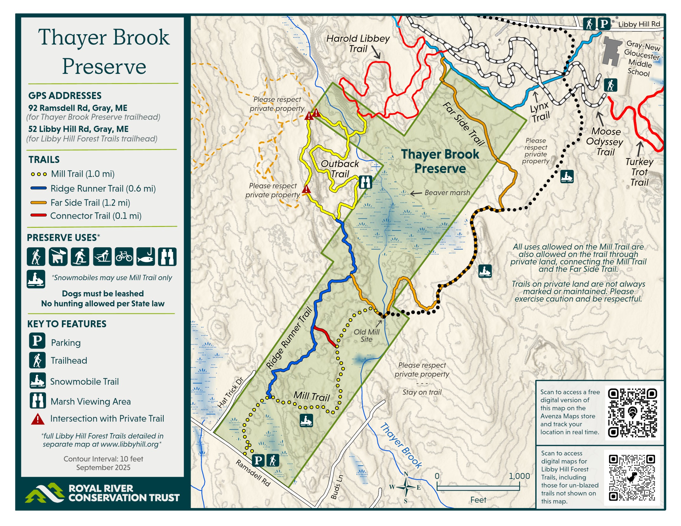
The 147-acre Thayer Brook Preserve contains sections of Thayer Brook and a large 60-acre beaver flowage with exceptional bird and wildlife values. The preserve includes a short segment of a regional snowmobile trail, as well as mountain biking, hiking, and cross-country skiing trails that integrate with the Libby Hill Forest.
Thayer Brook Preserve is part of a state-designated wildlife sanctuary that prohibits hunting and trapping but allows fishing. As a result, dogs must be on leash at all times.
4+ mile trail network


More information
Thayer Brook Preserve's trails connect to the Libby Hills Forest trails network, creating even longer loops or hikes from Ramsdell Road. Please abide by rules and regulations set forth by Libby Hill Forest Trails. Parking near Gray-New Gloucester schools (Libby Hill Road) provide convenient access to those trails.
Parking: There is a fourteen-space trailhead parking lot at 92 Ramdsdell Road, Gray, ME. This parking lot is plowed during the winter. Parking also exists at Libby Hill Road.
The multi-use Mill Trail (yellow blaze) (0.6 miles) begins at the Ramsdell Road trailhead and leads to a historic Old Mill site, which has been cleared to include a bench and scenic view of the beaver dam. From there, an unmarked snowmobile trail (black dots) continues toward the Far Side Trail. This section is intended for snowmobile use and is not blazed. No ATV use allowed.
The Ridge Runner Trail (blue blaze) (0.6 miles) departs from the Mill Trail and connects to the Outback Trail and marsh viewing area, part of the Libby Hill Forest Trail system.
NEW as of September 2025, there is a trailhead for the 1.2-mile Far Side Trail (orange blaze) halfway out on the Ridge Runner Trail that leads to the Old Mill site then bypasses around the snowmobile trail to link up with the former "Upper Trail", connecting to additional trails in the Libby Hill Forest Trail system.
The Connector Trail (red blaze) (0.1 mile) is a short link between the Ridge Runner Trail and Mill Trail.
A 3.4-mile Round the Marsh Loop trip around the beaver marsh may be formed by utilizing the Ridge Runner, Far Side, and Libby Hill Trails. Recommended route from the junction: Clockwise, starting and ending the loop at the junction of the Mill Trail and Ridge Runner. By going clockwise, you can take every single right turn (except left at the junction of Mill and Ridge Runner).
For a shorter 2.6-mile experience, follow the Mill Trail to the Ridge Runner Trail and then loop around the Outback Trail.
Accessibility: Trails are rocky and unsuitable for even the most adventuresome wheelchair users. Even the Mill Trail has rocks, slopes, and puddles that limit access for wheelchairs. Sections of the Ridge Runner Trail have bog bridges, as pictured below.

Thayer Brook Preserve is a component of the Libby Hill unfragmented habitat block. At 2,580 acres this is the 5th largest unfragmented habitat block (undeveloped forest) in Greater Portland. Along with Libby Hill Forest, the Thayer Brook Preserve is now one of the few protected lands within this undeveloped forest. Royal River Conservation Trust and Presumpscot Regional Land Trust are today prioritizing more work to conserve more of this undeveloped forest. Many years and considerable effort and focus by numerous individuals and organizations have brought us here.
Thayer Brook Preserve was established in 2022 and was acquired in part with funding from the Maine Outdoor Heritage Fund (MOHF), the Casco Bay Estuary Partnership (CBEP), and Land for Maine's Future (LMF).
- Preserve trails are open during daylight hours for biking, hiking, snowshoeing, and back-country skiing. Snowmobiling is permitted on the Mill Trail.
- Dogs are welcome but must be leashed at all times due to wildlife sensitivities unique to this parcel.
- There is no hunting or trapping on this property, due to the neighborhood’s designation by the Maine Legislature as a wildlife sanctuary (“the Gray Game Sanctuary”). Fishing is allowed.
- No ATV use allowed.
- No camping, overnight parking, fires, or smoking.
- Please respect postings on private abutting land.
Royal River Conservation Trust protects and stewards properties, including Thayer Brook Preserve, located within the traditional homelands of the Wabanaki. We strive to ensure that our properties are inclusive and accessible and provide opportunities for healing, education, and respite.
Libby Hill was named after Daniel Libby (1742-1826) who was an early settler and one of the first members of the Town of Gray Select Board. His descendants donated the land which became Libby Hill Forest.
An 18th or early 19th Century very primitive stone boulder dam (breached) crosses Thayer Brook very near the Mill Trail crossing of Thayer Brook. The stone dam is parallel to the beaver dams which form the upstream marsh and ponds.
Habitat
Thayer Brook drains to the Pleasant River which joins the Presumpscot River in Windham before heading to Casco Bay. Libby Hill separates the Presumpscot and Royal River watersheds; the nearby Gray-New Gloucester school campuses drain to the Royal River.
Thayer Brook Preserve is a component of the 2,600-acre Libby Hill unfragmented habitat block – the fifth-largest in Greater Portland. The preserve and abutting Libby Hill Forest represent two of the few protected lands within this habitat block.
The preserve has exceptionally large populations of white-tailed deer and beavers due to state hunting and trapping restrictions. The preserve is dominated by a large beaver marsh formed by more than six beaver dams which are home to enormous beaver lodges and large populations of birds. The beaver marsh was expanded significantly in 2010 thereby flooding a section of forest which now provides support for large bird nests built from beaver-chewed twigs and branches.
Beyond the marsh, most of the acreage of the preserve is dominated by “glacial erratics” – enormous boulders left behind as glaciers melted more than 10,000 years ago. The challenging rocky terrain is one reason the preserve has seen relatively little farming and no residential development over recent centuries.
On the road shoulders of Ramsdell Road, cut in half by Ramsdell Road near RRCT’s parking lot, a peatland bog, with peat and sphagnum upwards of four feet deep, supports high bush blueberries and beautiful Northern or Purple Pitcher Plants (Sarracenia purpurea). Peat and sphagnum in this bog are exceptional for their storage of carbon well beyond the levels of most forests and wetlands and this area. In the bog we’ve observed bogsuckers (aka American Woodcock, scolopax minor, timberdoodles).
Management Plan
Learn more

Thayer Brook Preserve
The 147-acre Thayer Brook Preserve contains sections of Thayer Brook and a large 60-acre beaver flowage with exceptional bird and wildlife values. The preserve includes a short segment of a regional snowmobile trail, as well as mountain biking, hiking, and cross-country skiing trails that integrate with the Libby Hill Forest.
Thayer Brook Preserve is part of a state-designated wildlife sanctuary that prohibits hunting and trapping but allows fishing. As a result, dogs must be on leash at all times.