
Intervale Preserve

Description
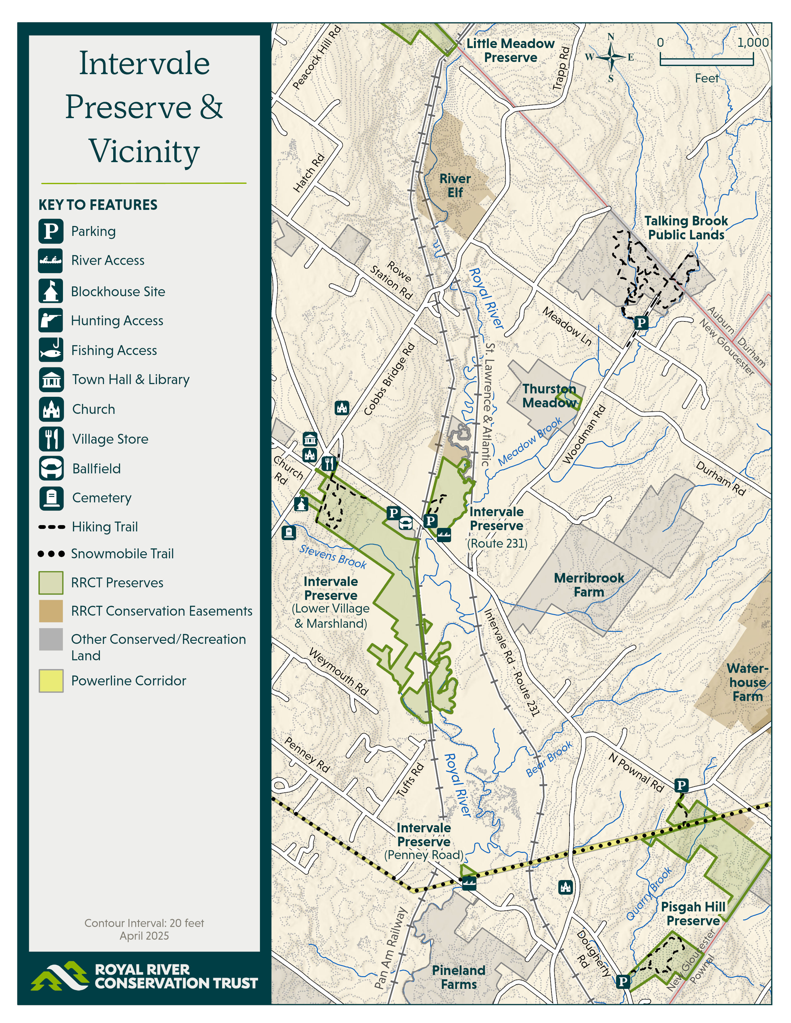
The 328-acre Intervale Preserve in New Gloucester provides some of the Royal River watershed‘s most valuable habitat for migratory birds, waterfowl, and game birds.
Intervale Preserve consists of three main parcels: the Route 231 parcel, the historic Lower Village and marshlands parcel, and the Penny Road river access site. The Intervale – the river valley between hills – is a beloved and iconic part of the New Gloucester landscape. The preserve is popular for its short hiking trails, Interurban rail trail segment, rich ecology, iconic historic village context, and access to snowmobile trails, hunting, and the Royal itself.
Warbler Trail (Route 231): 568 Intervale Rd, New Gloucester
Lower Village Trails: Intersection of Church Road & Gloucester Hill Road; 419 Intervale Road.
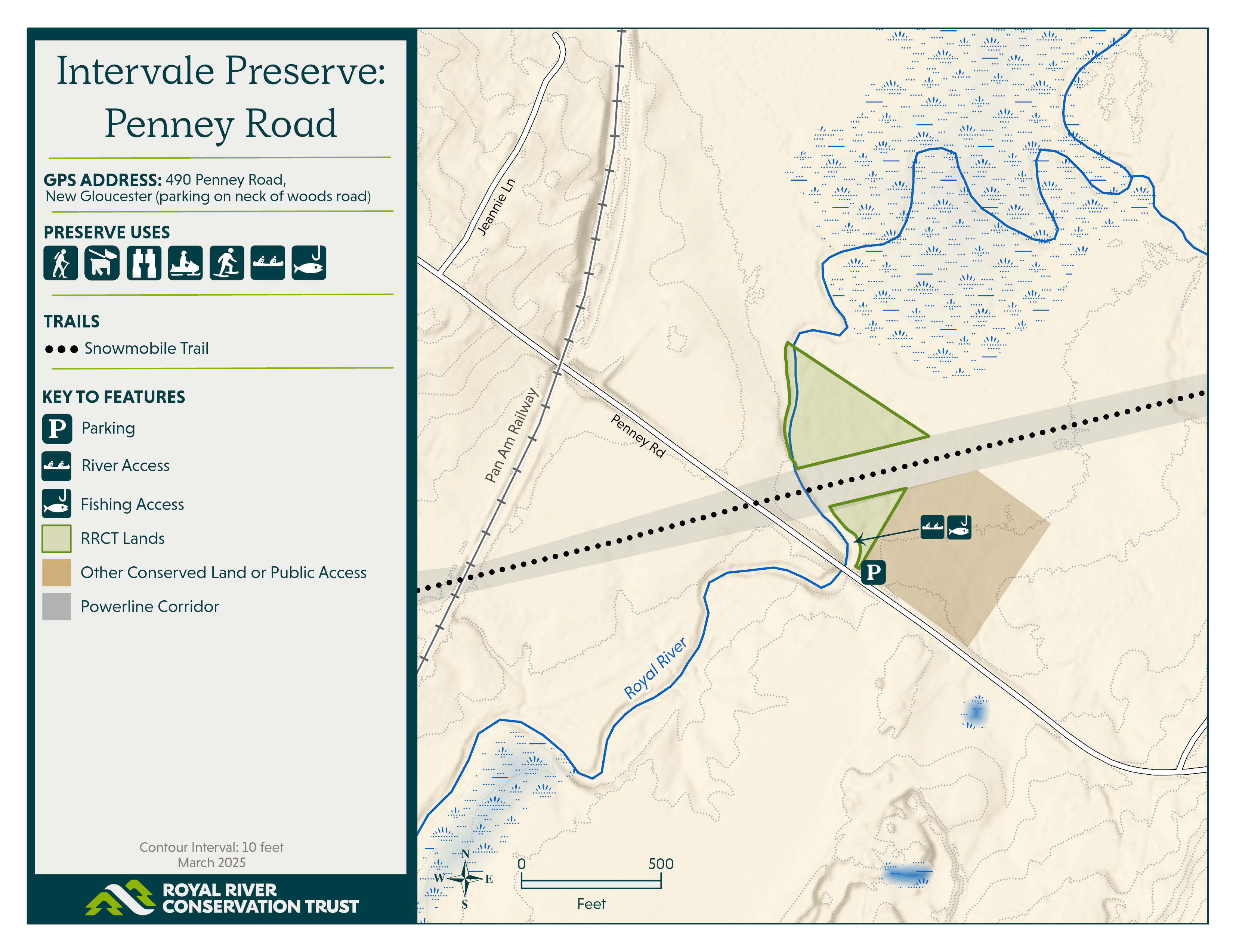
Penny Road water access: 490 Penney Road, New Gloucester


More information

Intervale Preserve abuts the ballfield now owned and long operated by the Gray-New Gloucester Little League (GNGLL). GNGLL was responsible for precipitating, and involving RRCT in, the Lower Village acquisition.
0.5-mile Warbler Loop Trail - 568 Intervale Road (Route 231): Look for a kiosk welcoming you to a flat half-mile loop trail that provides gentle walking with occasional bog bridging to avoid wet areas. Parking is available on the wide road shoulder and there is a picnic table at the beginning of the trail. There are two short spurs at the northern end of the loop that lead to views of the marsh – one with a bench entitled “Royal River Oxbows” created by local sculptor Jordan Smith. The marsh is a vantage point for observing migrating birds especially in May of each year. Nearby is a primitive hand-carry boat access point on the Royal River that allows for bank fishing and boat launching for paddling, fishing, and hunting by boat.

Lower Village and Interurban: Parking on Church Road shoulders allows to the Lower Village trails. An access trail marked with a yardarm sign and two boulders heads downhill from the intersection of Church Road and Gloucester Hill Road. Please do not park adjacent to the intersection or in the church parking lots. Alternatively, enter the preserve at the Interurban Trail (snowmobile trail) at 419 Intervale Road where it crosses Route 231 (Intervale Road). Parking on Grange Hall Road shoulders is also permissible.
A kiosk and bench welcomes visitors at the intersection of the Interurban Multi-Use Trail and the Foxcroft Multi-Use Trail. These multi-use trails are an important connection through town for snowmobilers. The primitive 0.8-mile Stevens Brook Trail runs through the Lower Village parcel woods, connecting to both the Interurban and Foxcroft Multi-Use Trails.
In 2022, the old log landing along the Foxcroft Trail was the focal site for a class of 8th grade students from the Fiddlehead School in Gray to enact their capstone projects. The capstone was intended to allow the students to complete projects that would provide benefits to the community and foster agency and creativity in the students. Projects included historical signage, a native edible plant garden, a stargazing platform, a bench, and a sensory meditation walk.
541 Intervale Road (Little League field): Foragers, hunters, and explorers are invited to visit segments of RRCT property that are currently trail-free.
490 Penney Road: The trailhead primarily serves as a primitive boat access point, a snowmobile trail, and an access point for hunting. Parking is available on the neck of the woods road (snowmobile trail). Watch for poison ivy. River access allows for bank fishing and boat launching for paddling, fishing, and hunting by boat. The stretch of river from Penney Road downstream to Wescustogo Park is a wonderful 8.1 mile high-water paddling trip. Landowner courtesies or steep scrambles are required for earlier take-out.
Preserve Water Access: Some areas of the Intervale Preserve are accessible only by canoe or kayak. Downriver access from Penney Road (paddle upriver and back) is best.
The first of over twenty tracts of land that comprise the Intervale Preserve, now a centerpiece of conservation in the Royal River watershed, was conserved in 1991. Many more tracts (both private and Town-held) were added in 2017 and 2018, which correspond primarily to the wet lowlands and the Penney Road water access. In 2021, RRCT acquired approximately 178 acres from Don & Lynne Chandler (spanning from Gloucester Hill Road to the Pan Am railroad), which – when combined with adjacent RRCT parcels on the west side of the Pan Am railroad, including a 4.5-acre donation of land – is referred to hereafter as the Lower Village parcel. Nearby farmland conservation (Waterhouse Farm and Merribrook Farm) projects in 2017 and 2018 added important conservation landscape context as did the creation of Talking Brook Public Land upstream.
One of the most notable features of the Intervale Preserve is the Interurban railbed. For two centuries (1740 to 1940) transportation on the river and the railroads (the Maine Central and the Interurban) defined the economy of New Gloucester. Straw and hay from what is now the Intervale Preserve were shipped to Portland and Boston for horses and packing. Barns and warehouses existed on what is now the preserve. The Portland-Lewiston Interurban historic electric railroad ran through the Intervale Preserve from 1914 to 1933. Today RRCT is re-assembling small, wet fragmented parcels of ownership as part of the growing Intervale Preserve, while beavers continue to reconvert drained marshes to lush habitat.
- Public access is welcome: hiking, snowshoeing, backcountry skiing, hunting & trapping with notice, birdwatching, fishing, and foraging.
- Dogs are welcome on leash or under strict voice control. Leashes are required adjacent to the Lower Village and private residences.
- Snowmobiles are allowed ONLY on the Interurban and Foxcroft Multi-Use Trails.
- Safe and responsible hunting and trapping are permitted with notice. Please annually register to hunt on RRCT property here. All trail users should wear blaze orange during hunting seasons.
- Please adhere to ‘leave no trace’ and ‘carry-in/carry-out’ practices. This includes dog waste!
- Bikes and horses are permitted only on the Lower Village trails.
- No camping, overnight parking, fires, or smoking.
The land that is now the Intervale Preserve is part of the ancestral land of the Abenaki nation, who are part of the Wabanaki Confederacy. We strive to ensure that our properties are inclusive and accessible and provide opportunities for healing, education, and respite. Through the conservation deed filed in 2022, RRCT acknowledges the central role of the Abenaki in the history of the lands that comprises the Intervale Preserve:
WHEREAS, for centuries prior to colonization of the North American continent by the British and the French, the land area currently known as the State of Maine, including that area of Town of New Gloucester that extends from Gloucester Hill to the Royal River, was part of the ancestral territory occupied and stewarded by the Wabanaki Confederacy that includes the Abenaki, Penobscot, Passamaquoddy and Maliseet tribes and the Mi’kmaq; and
WHEREAS for approximately six decades preceding the first colonial settlement in New Gloucester, the so-called French and Indian Wars raged across the east coast as native Wabanaki warriors sided with the French in efforts to halt the British expansion into Wabanaki lands; and
WHEREAS the Town’s first colonial inhabitants settled on Gloucester Hill in 1737 building nineteen wood frame homes and a sawmill on Stevens Brook, but after less than five years they abandoned their settlement in light of the local Wabanaki tribe’s resistance to takeover of their ancestral lands by the British; and
WHEREAS the French and Indian Wars continued for three more decades resulting in violence, retribution and atrocities by parties fighting for survival or dominion over the territory and natural resources of what are now known as the New England states and Canadian maritime provinces; and
WHEREAS some of the colonial settlers returned to New Gloucester in 1753, this time building a 50’ x 50’ two-story Blockhouse defended by two swivel guns and surrounded by 110’ long palisade stockade where 12 families and a garrison of six soldiers lived together for about six years during a period of violence, before hostilities subsided after the local Wabanaki retreated north…
The Intervale Preserve includes portions of the lot that was cleared in the 1750’s for the New Gloucester Blockhouse, a battleground during the French and Indian Wars.
Habitat
Intervale Preserve comprises approximately 328 acres of land under RRCT conservation ownership. The Royal River flows through the heart of the preserve and, along with Stevens Brook and other small, unnamed tributaries, expands to join approximately 1,200 acres of marshland both upriver and down river. This marshland and riparian floodplain are recognized in statewide databases as important habitats for inland wading birds and waterfowl, which is complemented by adjacent upland habitat towards Gloucester Hill Road.
Mapped wetlands – according to the National Wetlands Inventory (NWI) – constitute a sizeable 70% (230.5 acres) of the total acreage of the preserve. These include a mixture of multiple wetland classes, including scrub-shrub wetlands, forested wetlands, and emergent marsh wetlands lined by watercourses like Stevens Brook and the Royal River.
Management Plan
Learn more

Intervale Preserve
The 328-acre Intervale Preserve in New Gloucester provides some of the Royal River watershed‘s most valuable habitat for migratory birds, waterfowl, and game birds.
Intervale Preserve consists of three main parcels: the Route 231 parcel, the historic Lower Village and marshlands parcel, and the Penny Road river access site. The Intervale – the river valley between hills – is a beloved and iconic part of the New Gloucester landscape. The preserve is popular for its short hiking trails, Interurban rail trail segment, rich ecology, iconic historic village context, and access to snowmobile trails, hunting, and the Royal itself.